Whakarongo attenuation pond and wetland
We are currently constructing a pond and wetland on James Line to enable the continued residential development of the Whakarongo Residential Area.
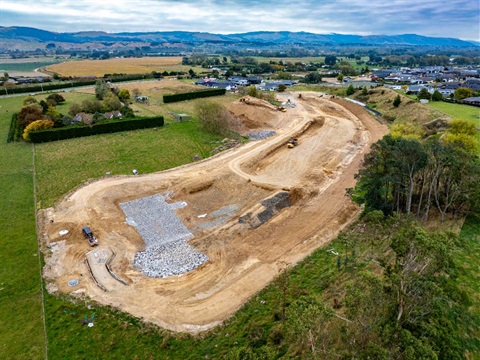
The pond provides flood storage for more than 500 lots of development in the coming years in the upper and lower terrace of Whakarongo.
The pond is about 375 metres long, 60m wide. The total catchment area it serves is 64 hectares. Construction is planned to finish in 2024.

Layout of pond and wetland design
This pond promotes best practice stormwater management
Stormwater modelling considered the needs of the various landowners and developers in the area to determine the best options for managing stormwater.
The best solution for the entire growth area was determined to be a central pond as opposed to a series of individual solutions by each landowner. The design will also allow landowners to subdivide and develop their land at their own pace as there is confirmed discharge points and serviceability.
The pond meets the hydraulic neutrality requirement under the District Plan and allows Council to successfully meet the discharge consent requirements set by Horizons Regional Council. The system is designed to hold and treat stormwater before flowing it into the Whakapokapoka lagoon.

Aerial view of pond and wider catchment area
We're working alongside iwi to develop a wetland
Rangitāne is advising us on how best to maximize encourage biodiversity and attract birds and other wildlife. This includes the planting of native trees which is deemed to start between September and November 2024.
By the numbers:
- 35,000 cubic metres of soil is being removed.
- 18.1 million litres is the capacity of pond (seven Olympic swimming pools)
- 23,833 native plants being planted in the wetland