Here’s a quick overview of the main updates in the draft reserve management plan.
A greater focus on working with Rangitāne
Ashhurst Domain and the surrounding area were originally the site of the Rangitāne village, Otangaki. The Domain is on the site of the old marae, and there were a number of burials in this area. This makes the site wahi tapu (sacred or special). We’re proposing that we work more closely with Rangitāne to ensure the area is managed respectfully and appropriately.
Changing the name to Otangaki-Ashhurst Domain
Rangitāne occupied this site (Otangaki) for hundreds of years, as the main entrance to the area by way of Te Āpiti (the Gorge). It was used as a main meeting area and significant cultural site until it became a public reserve. We’re proposing that the history of the site is reflected in its name.
Aligning with Te Āpiti and New Zealand Transport Agency plans
Te Āpiti Masterplan is a plan to develop Te Āpiti (the Manawatū Gorge) area into an activity hub and tourist destination. This will be complemented with the new highway to the east coast, which is currently under construction. When developing and updating signs and other wayfinding elements at the Domain, we will consider including information about these developments.
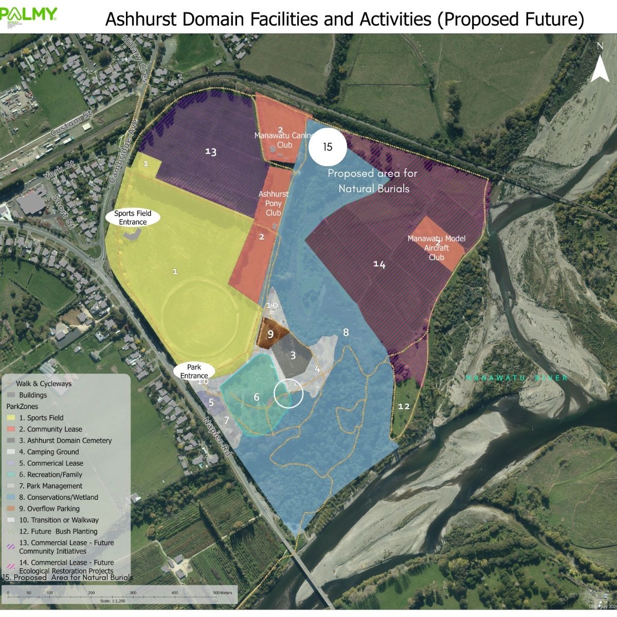
Better protecting the bush area
Ashhurst Domain is currently managed as a recreation site – which tends to give priority to people enjoying recreation activities. The native bush area in the Domain, while relatively small, is an important site for river swamp ecology and is also a site of cultural significance. The bush area has seen some damage in recent years from recreation users. Before drafting this plan, we commissioned cultural and ecological reports for the Domain. Both these reports recommended a higher level of protection.
We’re proposing to change the management of the native bush area only (see 8 in the map below). This means that the bush area will likely have some changes:
- Dogs will need to be on leash through the bush
- No walking off the official tracks
- No mountain biking in the native bush area.
Developing land on the lower terrace into a native forest and wetland
We’re planning to slowly and progressively restore parts of the lower terrace (which are currently leased for grazing) into native bush and wetland, as funding becomes available. See 14 in the map below.
Introducing a natural burial site
Natural burials have become more popular in recent years, as they're an eco-friendly alternative to traditional burials. They involve shallow, non-embalmed burials that encourage natural decomposition, often in areas restored to native bush. Members of the community, in consultation with Rangitāne, have identified a potential site near the northern boundary of the Domain for this purpose.
See 15 in the map below.
Developing land for future community projects
We’re also proposing that we set aside the upper terrace portion of land (which is currently used for grazing) for future community initiatives. This could include community gardens and orchards, or smaller spaces leased to individual clubs. See 13 in the map below.
Allowing food trucks to operate
The old café in the park was a well-loved and popular location, which provided park users with food and refreshments. Now that the café is no longer operating, we propose issuing licences to mobile food vendors who wish to trade in the reserve.
Continuing to manage the campground as an “off the beaten track experience’’
Our visitors tell us they enjoy the ‘off the beaten track” nature of the campground. We plan to maintain this type of experience with a focus on providing for short-term campers, rather than long-term residents. As visitor numbers continue to grow, we may have to review the level of facilities and the way we meet the day-to-day needs of campers.