Featherston Street safety upgrades

The busy intersection of Featherston and Rangitikei Streets, where 4 lanes collide in 4 directions.

We’re constructing the first section of the Featherston Street cycleway and pedestrian upgrades from January 2024.

Featherston Street is one of the most dangerous streets in our city, with 442 crashes in the past decade – two of these were fatal. These are only the crashes where emergency services attended, and do not account for near misses or minor crashes. Of those 442 crashes, 28 involved people on bikes and 19 involved pedestrians.

The Rangitikei/Featherston St intersection is the most dangerous intersection in the city and NZ Transport Agency Waka Kotahi (which owns the intersection) is planning on ‘raising’ parts of the intersection to help slow traffic in a separate project.

Our goals are clear

  • We want to reduce deaths and serious injuries for our vulnerable road users (children, people with disabilities, pedestrians, people on bikes).
  • We want to create more transport choices so people can choose how they get to where they live, work, shop and play.
  • We want to ensure that walking, cycling and public transport are safe, convenient and genuine transport options for anyone in our community.
  • We are supporting safer speeds outside of schools.

In early 2024, we’re constructing the section between Aroha and North Street

The key changes during this period are:

  • 2 new raised pedestrian crossings outside Central Normal and Palmerston North Boys’ High School
  • a separated uni-directional cycleway on both sides of the road
  • changes to the lane layout and light phasing at the Rangitikei intersection
  • placemaking elements to improve the character of the street.

This part of the project is primarily funded by NZ Transport Agency Waka Kotahi under its Streets for People programme, with Council contributing 10% of the total cost.

Construction is being carried out in two stages

  • Stage 1 (Aroha to Rangitikei Streets): From 16 January to mid-March.
  • Stage 2 (Rangitikei to North Streets): From mid-March to late April.

To minimise disruption to daily traffic, construction will take place at night, from 6pm to 6am Sunday to Thursday.

During these periods, road closures and detours will be in place. The road will return to normal during the day, but there may be reduced speeds and cones in some areas. There will be no work on Friday or Saturday nights, or on public holidays.

Bus detours in stage 2

Horizons Regional Council are detouring the 106 and 311 buses during stage 2 of the Featherston Street cycleway and pedestrian upgrades.

Map shows bus detours during stage two of Featherston street safety upgrade

For more information about the bus network, please visit the Palmerston North And Ashhurst Network page.

Businesses and schools along the construction route will remain accessible throughout the work period.

Cars must not be parked on the street within the construction zone after 6pm.

Construction of the rest of the Featherston Street cycleway is on hold

NZ Transport Agency informed Councils in November it was putting a hold on the funding for its Transport Choices programme until the new transport minister takes office.

This programme formed part of the previous government’s Climate Emergency Response Fund, supporting transport projects which help reduce carbon emissions.

Our Council has 3 projects which are funded by the Transport Choices programme:

  • Cycleway and pedestrian safety upgrades on Summerhill Drive/SH57
  • Cycleway and pedestrian safety upgrades on two sections of Featherston Street between Botanical Road to Aroha Street and North to Ruahine Streets
  • Construction of new bus stops and shelters throughout the city.

We have successfully completed the design phases for the cycleway improvements on Featherston Street and Summerhill Drive. We met all the milestones required by NZ Transport Agency during this period, ensuring our projects are ready for construction when funding becomes available.


We have successfully completed the design phases for the cycleway improvements on Featherston Street and Summerhill Drive. We met all the milestones required by NZ Transport Agency during this period, ensuring our projects are ready for construction when funding becomes available. 

This element requires javascript to be enabled.

Please wait while we load your map...

You can view the design of the new street by clicking on the images below.

Map shows proposed safety improvements on the layout for Featherston Street(JPG, 1MB)Botanical to Kowhai

Map shows proposed safety improvements on the layout for Featherston Street(JPG, 3MB)Wood to Ngata

Map shows proposed safety improvements on the layout for Featherston Street(JPG, 3MB)Ngata to Langston

Map shows proposed safety improvements on the layout for Featherston Street(JPG, 2MB)Langston to Ruahine

Five new pedestrian crossings

We are installing five new pedestrian crossings along the entire street.

Additionally, the existing crossings outside Central Normal and Palmerston North Boys’ High Schools will be raised to enable safer speeds at those school entrances.

We’re also looking at raising the crossings at the new locations. This may happen immediately or over time. New crossings are located - 

  • by Papaioea Park
  • Russell Street roundabout,
  • Elizabeth Street
  • Waldegrave Street (by Annie’s Takeaways)
  • by Pascal Street

Crossing locations were identified by the community and by stakeholders at our co-design sessions. People will also still be able to cross safely at traffic light intersections also.


New bus stops

In-lane bus stops

In-lane bus stops at busy intersections such as Featherston Street serve several important purposes that improve public transit systems, safety and overall traffic flow.

By allowing buses to pick up and drop off passengers without pulling out of traffic, in-lane bus stops minimise dwell time—the time a bus spends stopped at a stop. This reduces delays for both buses and other vehicles, making the transit system more attractive to passengers and improving overall traffic flow.

In-lane bus stops also help to improve the reliability of bus services by minimising delays caused by traffic congestion. Buses can maintain their schedules more effectively when they don't have to navigate through traffic to reach a stop.

They also improve safety outcomes by reducing the need for buses to merge back into traffic after stopping. This minimises potential conflicts between buses and other vehicles, pedestrians, and cyclists, particularly at busy intersections such as Featherston/Rangitikei where interactions between different modes of transportation are more frequent.

Bus stops are primarily in the same location as they are now

A couple of bus stops may have moved over a small distance either side to enable more parking spaces for businesses.

Due to the separated cycleway, buses will stop in the traffic lane. The average stop time for our buses in Palmerston North is 15 seconds. We tested the impact of in-lane bus stops at each location on Featherston Street.

A separated uni-directional cycleway

A cycleway on both sides of the road

People will travel in the same direction as motorists on a uni-directional cycleway, or one-way cycleway that run son both sides of the road.

The cycleway will have a separation barrier between the vehicle and bike lanes. These will be made of rubber and/or concrete, which are currently used in other cities.

We have tested that they’re suitable for rubbish/recycling/emergency services. Planter boxes will not be used. This was the preferred cycleway option identified by everyone during the co-design workshops.

At traffic light intersections, people on bikes will continue to wait in the green stop boxes if turning right. Traffic lights will also give them a head start before the cars.

How we chose the cycleway design

The cycleway becomes a shared path along Takaro Sports Club, near Botanical Road

A shared path is where people on bikes and pedestrians share the footpath.

This is not safe to do in any other location along the street due to things like higher vehicle speeds, significant number of conflict points such as driveways and side streets which causes greater safety risks (shared spaces are best in recreational areas like the river, where if there is an issue a user can wait on the grassy area to the side of the path rather than in a traffic environment).  

We can have a shared space in this area only as there is only one driveway for the sports club, which we have done to maintain the same number of traffic lanes at the Botanical Rd lights following community feedback.

Parking, no median and right-turns into busy side streets

A significant amount of on-street parking is being removed

This is needed to be able to fit everything we want into the available road space. We have prioritised parking where possible along the street and worked with businesses to do this, but there will be a noticeable reduction in parking spaces.

There are major reductions outside in the central part of the street around Palmerston North Boys’ High School/Mitre10/Central Normal School, but we will make additional drop off zones/time restricted parking on side streets for school drop off/pick up.

There are a couple of areas where there is also removal of parking outside some small businesses. Most businesses along the street still have parking outside their location except for a few.

The reduction in parking for small businesses around Lombard Street is due to the crossing by Central Normal becoming a raised crossing to improve safety for these young children – especially as some parents who previously parked on Featherston Street will now likely park on side streets like Taonui or Lombard Street to drop off their children. This type of crossing takes up more space, and because there are side streets in close vicinity (Aroha and Campbell) that means there is no space for parking due to issues with visibility, sightlines, space and safety.

The removal of on-street parking by Bourke Street (near Central Pharmacy, Kauri Health and Annie's Takeways, Botanical Laundry) is primarily driven by the installation of a raised pedestrian crossing near the Annie’s Takeaways entrance and maintaining a right-turn bay into Bourke Street. It's important for us to maintain right-turn bays for all side streets with more than 3,000 car movements per day to ensure safety. The location of the raised crossing was identified by the public during the co-design process as a crucial point for a safer crossing to Central Energy Trust Arena. The new crossing will help people accessing these businesses from side streets. Even if we removed the crossing, there is still no space available for on-street carparks due to the right-turn bay requirement. These businesses have an off-street carpark, and we will add time restricted parking on side street to help customers continue to access them.

Read more about how we reviewed the parking use

There will be no median along parts of the street, and only busy side-streets will have right turn bays

We are required to have right hand turn bays for streets that have more than 3000 vehicle movements each day otherwise our design wouldn’t pass independent safety audits. Right hand turn bays help traffic move into side streets without holding up traffic behind them, but due to their size there isn’t enough space to provide parking in the locations where these are. The median strip is removed in most locations to support on-street parking where possible.

Keep clear zones trial continues outside McDonalds, Mitre 10 and Ngata Street

They yellow keep clear boxes at these entrances help motorists turn right into these businesses or Featherston Street. They require everyone’s cooperation to work, and as a motorist you should never wait or stop your car in one.

There are parking spaces in most parts of the streets for residents

In some locations, we have been able to retain parking in residential areas, but people may have to walk a bit further to get to these than they do now. Our parking surveys show the side streets are currently underutilised and have plenty of capacity to offset the parking loss on Featherston Street.

Safer intersections for everyone

Changing lane layouts at Rangitikei and Ruahine traffic light intersections

We are moving from three lanes to two lanes at both intersections.

There will be a merged left/straight lane, and a right lane only. Lights will be phased at these intersections and those next to them to minimise congestion as much as possible. This was trialled at the Rangitikei Street intersection as part of our design process with different light phasing tested during the weeklong trial to determine the best sequencing.

Read more about the trial

Safer roundabout at Russell Street

The area around the Russell Street roundabout will be far safer for all users, with new crossings to enable people to cross at this key location – especially children going to Russell Street School.

The cycleway merges into a shared pathway at the roundabout so that people on bikes will cross the intersection using the new pedestrian crossings.

Waka Kotahi is upgrading the SH3 Rangitikei St intersection

As part of this project, Waka Kotahi is looking at ways to make the SH3 Rangitikei Street intersection safer. Waka Kotahi is planning on installing a raised intersection or raised platforms at this location. Raised intersections and platforms help to keep people safe by encouraging drivers to slow down, reducing both the likelihood of crashes and the severity of injuries if crashes do occur.

A design is being worked on, and further updates will be provided. Find out more on the project page or contact the team at rangitikeist@nzta.govt.nz

Parking changes around Central Normal School

We’re making some changes around Central Normal School in early-2024.

As you’ll be aware, there will be some changes to the area around Central Normal School as part of the Featherston Street cycleway and safety improvements from early 2024.

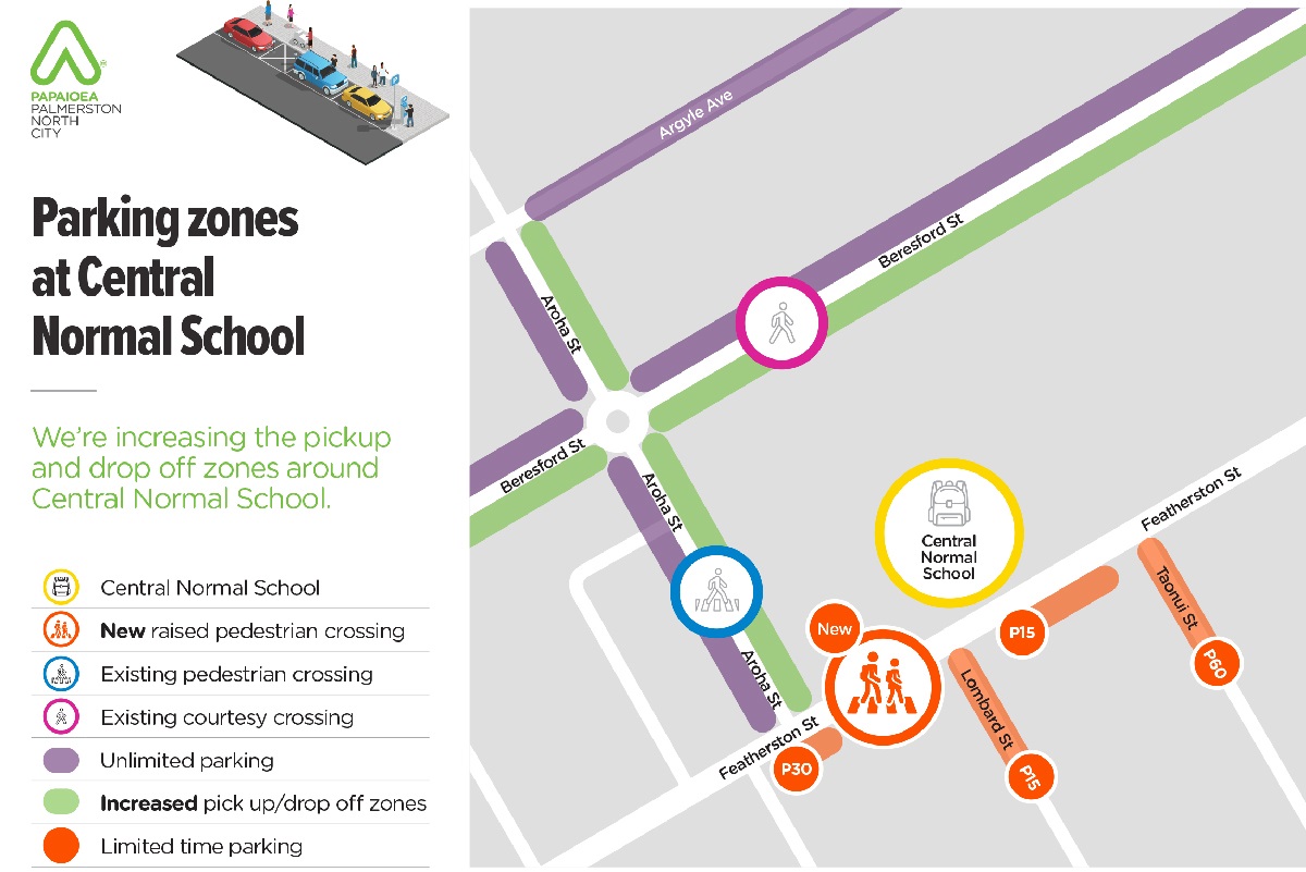
The main things changing around the school are:

  • A new raised pedestrian crossing on Featherston Street
  • New pick-up/drop-off zone on Lombard Street
  • Extended pick-up/drop-off zones on Aroha and Beresford Streets
  • P60 time restricted parking on Taonui Street
  • Removal of pick up/drop off zone on Featherston Street

Construction between Central Normal and PNBHS is starting in early-2024

Our contractor has indicated they can start in early January with the section outside Central Normal School. Some of this construction may overlap at the start of the school year.

The sections outside of North to Aroha Streets have been delayed due to a funding pause by Waka Kotahi – NZ Transport Agency until the new Transport Minister takes office.

We co-designed the street alongside our community

This project has seen us carry out the most significant community engagement our Council has ever done for a transport project. At first, we sought feedback from the community before meeting with more than 130 businesses, schools and organisations to discuss their needs. We then invited representatives from each of these groups to come together over a series of workshops to co-design the cycleway and other safety improvements. The cycleway design proceeding to construction was supported by the majority of people at co-design. Our designers used all that feedback to design the new street.

Many residents, organisations and motorists have had to compromise on the design adjustments of the new street, and for Central Normal School it meant reconfiguring the pick-up/drop-off zone near the front entrance.

Proposed parking zones for Central Normal School

Parking on Featherston Street is being removed to accommodate space for uni-directional separated cycleway

We explained at co-design that if a uni-directional cycleway proceeded, only limited parking could be provided on one side of the street, and only in isolated areas. Seven parking spaces remain along the school front, but they are on the opposite side of the road for small businesses – as many of these do not have private off-street parking spaces, while businesses near the school on the same side all have large amounts of off-street parking.

Part of the cycleway design includes upgrading the school’s pedestrian crossing as there are plenty of side streets within the immediate vicinity of the school that can be better utilised to provide parking for picking up and dropping off pupils.

Limitations on parking in this area included raising the school’s pedestrian crossing, maintaining bus stops, and providing parking for small business across the road.

Currently, there are very few designated pick up/drop off zones around Central Normal School

Pick up and drop off zones are designated spaces for parents to park around 9am and 3pm. Residents, employees and customers can’t park in these areas at these times – allowing more space for you to drop off your children easily and safely. Currently, there are only a few spaces on Beresford and Aroha Streets where these rules apply, so we’re increasing the areas around Central Normal where these rules apply.

Increasing and relocating pick-up drop-off zones around Central Normal School

When elected members decided on the cycleway design in June, we explored how we could off-set the parking loss on Featherston St by better utilising other streets within the immediate vicinity of Central Normal. Central Normal has several of these, including Beresford, Aroha, Argyle, Taonui, Lombard and Campbell Streets.

Aroha/Beresford

Pick up and drop off zones will now be extended along the entire length of Arohoa and Beresford on the sides closest to the school, as these rules currently only apply to small sections of each. This will free up more space on these streets at pick up and drop off times.

Lombard/Taonui

We are installing P15 signs on sections of Lombard to enable pick up/drop offs. We’re also installing P60 signs on Taonui, which currently allows a mix of P120 and P240 restrictions – meaning they are currently used by employees of nearby businesses for extended periods.

Argyle

Our planning team have advised Argyle Street could be better utlised as a drop off/pick up zone as it provides a safe walking route within 200 metres of the school’s Beresford entrance (which is the same distance to park on Taonui and walk to the school entrance via the new raised pedestrian crossing).

Using Argyle is a good substitute for those of you who previously used the pick up/drop off zone on Featherston Street as it not only reduces the number of vehicles on Featherston Street and at the Rangitikei lights, but because you can still use the direct exit onto Rangitikei. Using this street will make your journey quicker by eliminating the time it takes to reenter the traffic lane on Featherston and waiting at the traffic lights during peak times.

We’ll monitor parking before and after construction

Part of our monitoring and evaluation after construction is to carry out more parking counts on these streets to determine if any of the parking zones need reviewing. You might also see us walking around to survey you to get your feedback.

Upgraded pedestrian crossing on Featherston to make it safer to cross from Taonui/Lombard/Campbell Streets

The new raised pedestrian crossing will provide a visible platform for your whānau to cross Featherston Street safely and get to or from school.

They raise pedestrians above the level of the road to make them more visible to drivers, reduce the total crossing distance and force vehicles to slow down. We plan to raise the pedestrian crossing on Aroha Street in time too.


How we chose the cycleway design

A shared path option was ruled out early in the investigation stage as it posed a major safety risk to all road users due to the number of driveways and how busy the street is.

There was the possibility of cyclists and pedestrians crashing due to different speeds, as well as cars moving out of driveways also striking one of them. As it’s next to a busy street, any crash on the footpath space would also mean someone would likely have ended up in the live traffic lane where cars are moving. Shared paths work well in recreation areas, such as along the Manawatu River walkway, but not next to busy roads.

Co-design workshop attendees narrowed the cycleway design to two options

The first was uni-directional, or a one-way cycleway, on both sides of the road.

Artist's impression of one-way cycleways on both side of Featherston Street

The benefits are bike riders travel in the same direction as traffic, it’s more intuitive for drivers who only need to look one way when entering or exiting side streets or driveways and it was consistent with other cycleways in the city. This is also the current cycleway on Featherston Street, so it’s a familiar design to everyone. They are also significantly safer than the other option. The downside is they take up more road space so there is a larger impact on on-street parking.

The other option was a bi-directional cycleway on one side of the road.

Artist's impression of two-way cycleways on northern side of Featherston Street

This is where you have a cycleway on just one side of the road and people on bikes travel in both directions on it. These are less safe for people on bikes, confusing for people learning to ride, inconsistent with other cycleways in the city and motorists would have to remember to look in both directions when exiting driveways or side streets.

These cycleways allow for more parking to be retained, but there are also several crashes that happen around these cycleways each year. For this option, it could have been on either side of the road.

The uni-directional, or one-way cycleway option, on both sides of the road was favoured by most people at co-design and also scored the highest for safety.

Elected Members considered both options and decided to proceed with the option where it is on both sides of the road.

The cycleway will be 1.8 metres wide and there will be a separation barrier between the cycle lane and the road. There will be no separators in front of driveways or at intersections. Green paint will indicate it is a cycleway like in other locations, and cars cannot park in the cycleway.

We’ve completed pedestrian, cycling, scooter and parking counts

Parking

We’ve reviewed parking use on Featherston Street and the side streets. This involved using camera software that recorded each hour how many cars were parked in a spot. This occurred between 7- 8am on a weekday, and 8am-8pm on a weekend. We did this on a typical day – for example there were no events, typical overcast weather day, during school term.

These maps show the weekday results – weekend results are similar but it’s less busy near the schools.

Red means that when the car drove around the carparks were usually full. Blue shows some were in use and green are the areas where the parks weren’t being used much.

These show us that the areas around Rangitikei Street has the highest demand for parking and then the area around the hospital. People tend to park on the southern side of the road (the Countdown/Mitre 10 side) more.

When looking at the occupancy of carparks in these areas, between Botanical Road and Rangitikei Street, during the busiest time 30.2% of on-street carparks were used. Between Rangitikei and Ruahine, 40.7% of parks were used.

These maps show that there is capacity for more people to park on side streets too. We’re going to be adding time limits in some of these areas to further help the schools and businesses.

image of a map showing the carpark usage along Featherston Street

View the table which summarises parking outside key locations

View the table which summarises the pedestrian/cycling/scooter counts(PDF, 104KB)

We tested the light phasing for the new Rangitikei layout

In late August, we spent the week testing different light phases to determine how we can move people through the new layout as efficiently as possible.

We trialled the merging of the left hand turning and straight-ahead lanes on Featherston Street, on both the east and west approaches to Rangitikei Street (SH3). We also trialled changes to the signal phases to match the future use of the cycleway.  The maximum speed was reduced to 30km/h through the area during the trial.

Travelling east to west during the trial took an average 3.25 signal phases to get from Ngata Street through the intersection, compared with 2.8 signal phases outside of the trial. Travelling west to east during the trial took an average 2.9 signal phases to get from Taonui Street through the intersection, compared with 2.2 signal phases outside of the trial. Waka Kotahi consider that the effect on the operation of the intersection during the trial was ‘less than minor’.

We’re now looking at the phasing design now and looking at a few options. This includes people on bikes going on their own light (using a sensor type technology), all pedestrian movements at once, and having both the cyclists and pedestrians move together in a barn dance. We are looking into these options more to determine any flow on impact.

We also have trialled keep clear boxes outside McDonalds, Mitre10 and Ngata Street.

Read the summary of public feedback about the trial(PDF, 2MB)

Cycleway separators

We’ll be using separators to physically separate people on bikes to those in vehicles. The separators will likely be a mix of concrete and rubber low round raised platforms, such as below.

Image shows three concrete blocks seperating cycleway and the main road

At conflict points, such as busy areas or near intersections, they may also have vertical flexi posts – like what is on Main Street.

The separators need to be low so that we can continue to have rubbish and recycling services in the city. Residents will continue to place their wheelie bins, glass crates and rubbish bags on the kerb like they do now – they should never be placed on the separator or in the bike lane.

Once the cycleway is installed, and only at off peak times, rubbish and recycling trucks will drive with one wheel on either side of the separator.

Whilst the truck would be in the cycle lane, it would be obvious to people on bikes, so they would have an option to either use the footpath or the live traffic lane instead. We will be working with our own resource recovery team and sending info to other waste companies in the city about what they need to do once the cycleway separators are installed.

We’ve also talked to emergency services:

As part of this project, we talked to emergency services about their needs. Things we queried with them were the impact of removing median lanes, installing raised crossings, changes to lane layouts at intersections and the separation barrier. Emergency Services will likely use the road as normal for most emergencies, but if they really need too, they would also be able to use part of the cycle lane.

We’ll be talking to emergency services more as the construction draws closer.

We've worked closely with a range of stakeholders

This project has seen some of the most significant community engagement our Council has ever done.

We acknowledge change can be hard as we often fear the unknown and are naturally cautious when it comes to new infrastructure projects. But we also know people can adapt quickly to new norms.

We started our engagement on this project in September 2022

At first, we sought feedback from the community, and met with more than 100 businesses, schools and organisations to discuss their needs. We then brought representatives from each of these key stakeholder groups together in one room over a series of workshops to co-design the street and pick the best outcomes.

Our co-design process took place over three workshops and involved residents, businesses, motorists, people with disabilities, schools, board members, medical staff, emergency services, children, and a wide range of others. This process saw us work collectively to consider the needs of all road users. Our designers used all that feedback to design the new street.

During that design phase, we also talked to businesses about their specific needs, such as parking. We’ve been able to find solutions for parking for most of these businesses, but there are a couple of cases in which there is simply not enough space to provide parking on the road, and so we are considering solutions such as installing appropriate time restrictions on the side streets to help offset the number of spaces lost on Featherston Street. Our parking surveys show that most side streets are currently underutilised.

Check out the design section on this page for an outline of the design changes and why they’ve been made for sections of the street.

Read the engagement reports below for a summary of our community’s involvement

In late 2022, we completed the first phase of community feedback on the proposed upgrade. This focused on the section from Botanical Road to North Street.

We received more than 210 submissions online, along with extensive feedback at our online and drop-in sessions.

 Read our Engagement Summary

In March 2023, we held our first co-design session which is primarily focused on the area between North Street to Aroha Street (Boys' High to Central Normal).

Read the summary of the first co-design session for Featherston Street

Read the Featherston Street Engagement Summary March/April 2023

In May 2023, we held our second co-design session which is focused on the three proposed cycleway options between North Street to Aroha Street.

Read the summary of the second co-design session for Featherston Street

In June 2023, we held our third co-design session to gather feedback on two proposed cycleway options (a one-way cycleway and two-way cycleway on the north side) for the full length of Featherston Street between Botanical Road and Vogel Street.

Read the report of the third co-design session for Featherston Street

In August 2023, we tested some of the changes in the final design and ask for the community's feedback on these.

Read the engagement report from the trial period

We also held a placemaking co-design workshop in August to identify the type of placemaking elements people would like to see on Featherston Street as part of this project.

Read the placemaking summary report(PDF, 5MB)

Council meetings about Featherston Street

There have been several Council meetings about the Featherston Street cycleway and safety improvements. These meetings are also recorded on our YouTube channel.

During this time some elected members have also talked and met with some businesses, and attended co-design sessions. Official Council meetings started in 2022 when we were notified we could receive funding from Waka Kotahi.

Read more on the meeting agenda document

Watch the meeting recording

In June, Council considered the stakeholder engagement, initial engineering, and feedback from co-design to determine what type of cycleway to proceed with.

Read more on the meeting agenda document

Watch the meeting recording

In September there was a workshop where Elected Members reviewed the design and asked questions.

Featherston Street cycleway and Summerhill Drive cycleway presentation document(PDF, 2MB)

Transport choices for Featherston Street cycleway detailed design(PDF, 22MB)

At the end of September elected members reviewed the final proposed design, before Waka Kotahi also reviews it.

Read more on the meeting agenda document

Watch the meeting recording

Projects like this unlock funding for major roading changes in our city


We are working alongside Waka Kotahi on more than 70 transport projects over the next 30 years to help improve safety and the efficiency of people and goods around our city. This is called the Palmerston North Integrated Transport Initiative (PNITI). Waka Kotahi is our key transport partner and major funder for these projects.

Projects such as cycleways, pedestrian improvements, improving intersection safety, enabling better public transport and slowing down traffic in our urban areas are key steps in our partnership, which will in time see us create an outer ring road around our city for trucks to use as well as in time a second river crossing. These projects work hand in hand and can’t be done in isolation. The Featherston Street cycleway is one of the 70 projects included in this plan.

Read more about the Palmerston North Integrated Transport Initiative (PNITI)(PDF, 27MB)

Read more about the Urban Cycle Network Masterplan